 | |  |
|
 |
  
 
Experts /
Social /
Photos /
News /
Jobs /
Articles /
LBS /
Contact /
Advertising
This newsletter is online
HERE
- Previous Edition
- Facebook

Dive into Python - Python from novice to pro
| | |
Hello GISuser... and welcome to our Tuesday Geotechnology news roundup. Well, yesterday was the date for Americans to get signed up under the affordable health care act and a flurry of activity was seen, as could have been expected. Apaprently there were almost 50 million Americans without insurance and CNN tackled that issue with a map. The map shows "the number of individuals who have selected a marketplace plan" in various states, according to the U.S. Department of Health and Human Services ( See More HERE). CNN wasn't the only publication using a map to convey as Forbes also published some data visualizations. Some cuonties also employed mapping technology to help people locate health care insurance providers, like Pima Arizona for example - a great idea really!
Moving forward, news from TomTom this week as the company rolls out a renewed strategy for their business solutions unit along with a new name - enter TomTom Telematics (details below); Orbit GT has released their iOS Mobile Mapping viewer 10.5 - the iOS PanoViewer App gives access to all types of mobile mapping data, based on a spherical camera system - See more here. Much more news is found below and on GISuser.com - have a great day all and enjoy this Spring Day!
Comments or Tips? Please Contact Us
|
 |
 |
 | | |
 |
Sponsored by The GEOINT Symposium
The annual GEOINT Symposium is the nation's largest intelligence event. GEOINT 2013* will be held in Tampa, FL, April 14-17. Don't miss a full day of science and technology discourse, three days of keynote addresses and panel discussions, more than 30 hours of training and education sessions, and 250+ exhibits.
|
| |
 |
 |  |
|
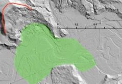 USGS is working with partners to provide up-to-date Washington State Landslide info - USGS scientists are supporting state and county agencies responding to the event. It is a collaborative effort, with many working hard to provide assistance, assess the situation, and alleviate impacts as the hazard isn't over. For example, future rain conditions or snowmelt from nearby mountain tops could exacerbate the situation. Current research is focused on gathering more LiDAR imagery and aerial photographs to help with mapping the extent of the landslide.
 The Best and Worst terms to Use on your Resume
A new Study Ranks Best and Worst Words to Use in a Resume. So if you happen to consider yourself as a dynamic go-to person who's results driven and a team player then you better think again because you sound exactly like everyone else who's blindly copying these adjectives into their CV and hoping to land that dream job!
Colorado Western Slope GIS Feasibility Study Video - This Colorado Western Slope GIS Feasibility Study video was developed for a client considering using GlobalMapper* for an Oil & Gas project. This video was developed for a client considering using GlobalMapper* for an Oil & Gas project.

 TomTom Business Solutions renamed to TomTom Telematics
The new name reflects its strong position in providing Telematics Software as a Service (SaaS). The SaaS platform, WEBFLEET is the company's premiere product that helps businesses to improve vehicle performance, save fuel, support drivers and increase overall fleet efficiency.
Feature your next PR here... contact @gletham for info!
GeoTech Newsmakers
Got news... Send your news to

More Tech News!
LBSZONE.com |
SymbianOne |
Amerisurv.com |
LidarNews.com |
3DMachineControl
|
|
|
|
| | |
 | Sponsored by LizardTech
LizardTech offers software solutions for managing and distributing geospatial imagery, and is the creator of the MrSID® technology, a powerful wavelet-based image encoder, viewer, and file format. LizardTech's line of geospatial software products include GeoExpress®, image compression and manipulations software, Express Server® for high-performance image delivery and publication, and LiDAR Compressor™, which turns giant point cloud datasets into efficient MrSID files.
|
| | |
|
| |
|
|

Each day in this section we'll update you about Geospatial conferences, training, seminars,
webinars, and relevant events. Feel free to make a suggestion for future consideration and be sure to see our Events Calendar.
 FOSS4G PDX 2014 -
FOSS4G, to be held September 8th-13th in Portland, Oregon, USA is the premier international conference on open source geospatial technologies. With two days of workshops followed by three days of presentations and academic papers, FOSS4G features a diversity of attendees and participants spanning academia, industry, and government.
FOSS4G PDX 2014 -
FOSS4G, to be held September 8th-13th in Portland, Oregon, USA is the premier international conference on open source geospatial technologies. With two days of workshops followed by three days of presentations and academic papers, FOSS4G features a diversity of attendees and participants spanning academia, industry, and government.
HxGN Live -
You'll see technology previews, meet Intergraph experts, and enjoy great entertainment. You'll also hear an inspiring keynote by Steven Cost, our new Intergraph Security, Government & Infrastructure (SG&I) president. Find out about the great things SG&I is doing in your industry. MGM Grand, Las Vegas, June 2-5, 2014
Geoint Symposium 2014 -
The GEOINT 2013* Symposium takes place April 14-17, 2014 at the Tampa Convention Center in Tampa, Florida. The GEOINT Symposium is the preeminent event of the year for the defense, intelligence and homeland security communities.
Google I/O 2014 - Details of registration, keynote livestream, and sessions - We just launched the Google I/O 2014 website at http://www.google.com/io. Play with the experiment, get a preview of this year's conference, and find out more details about registration. Registration to begin April 8 with attendees selected randomly.
Let GISuser help promote your next event or webinar! Contact us
|
|
|
|
| | |
 | Sponsored by the University of Denver
The University of Denver's college of professional and continuing studies, University College, and the Department of Geography are partnering to offer a Master of Science in Geographic Information Science delivered online for working adults. This online Master's Degree in Geographic Information Sciences recognizes the emerging importance of geographic information science and the importance of integrating advanced study in geographic information systems, remote sensing, and global positioning systems with traditional studies in human, cultural, and physical geography.
Learn more about the University of Denver's Master of Science in Geographic Information Science
|
| | |
|
| |

GeoJobsBIZ from Spatial Media - Our fabulous, new resource for GIS, geo technology, surveying, mapping and positioning career opportunities and resumes. Check it out at Geojobs.Biz.
 JavaScript App Product Engineer
 - Are you eager to work on cutting-edge web technology? Do you have a proven track record of delivering high quality results, while thriving in a quickly paced environment? Bring your expertise in web development to the team that designs and supports our dynamic and engaging Operations Dashboard for ArcGIS web application. This is a unique opportunity to bring new capabilities to the Esri user community, allowing them to monitor, track, and report events driven by real-time data.
Instructor-Server -
Use your teaching skills and GIS knowledge to help our customers be successful with our innovative GIS software. Esri instructors provide a rich learning environment through hands-on training, instructional delivery, and facilitated activities.
Location Analytics Product Engineer - Are you a highly skilled individual who has what it takes to drive quality and participate in the the release of sophisticated location analytics technology? Join the team responsible for releasing a software system that runs on browsers, mobile devices, enterprise class servers, and in the cloud.
Solution Engineer - Commercialt -
Are you passionate about technology and keeping up to date with emerging trends? A self-starter, problem solver, and a natural evangelist? Put these qualities to work as a Solution Engineer, where you'll have the opportunity to help shape and deliver on a strategy to demonstrate how Esri's ArcGIS platform can enable organizations to discover, use, make, and share maps for any device, anywhere they are.
Post your job online with GeoJobsBIZ and you'll also get attention via the GISuser LinkedIn Group, FB Page, and Twitter!
(To list your HOT Job for some added exposure and support our efforts, contact jobs at
gisuser.com - List your Career opportunity online for 60 days and right here in the newsletter)
Send your job ad to jobs[at]gisuser.com
<< Go To The career center >>

Glenn maintains a fun, educational, and informative tech blog
AnyGeo - Anything geospatial. Look for tips, tricks, and commentary about GIS, Geo, mobile, social, and basically, anything geospatial!
|
| | | | |
 | Sponsored by Trimble
Be ready for anything with the Trimbler Geo 7 series. No matter what gets in your way Geo 7X handhelds offer two powerful technology innovations so you stay productive when the going gets tough. Trimble FloodlightT technology keeps you working when heavy overhead cover obstructs weak satellite signals. When occupying the position is not possible, turn to Trimble WavepointT technology to capture offset measurements and still get the position, despite dangerous conditions or right-of-way challenges-saving time each day while getting previously impossible work done.
To learn more www.trimble.com/geo7.
|
| | | | |
|
Did-U-Know you can connect with more than 35,000+ other GIS professionals via LinkedIn via our popular GIS Professionals Group - Also, connect with 2500 others via the GISuser facebook page.
 Dive Into Python-Free 328 Page eBook - Whether you're an experienced programmer looking to get into Python or grizzled Python veteran who remembers the days when you had to import the string module, Dive Into Python is your 'desert island' Python book.
GPS Tracking of Company Vehicles: The Complete Reference Guide - GPS vehicle tracking has gained popularity in many segments of the business world. Two main reasons account for this increase in popularity: a maturing technology with falling prices, and the desire for increased employee productivity.
Building a Smarter IT Infrastructure for Local Government - More and more local governments' web-based services are available every year. While convenient for users, it's on your shoulders to seamlessly meet your organization's increased application delivery demands. In fact, local government's success in providing online programs depends on your ability to ensure that users always have fast and secure access to online applications.

ADVERTISE with Spatial Media LLCSpatial Media LLC GISuser.com Media Kit - our Media kit with rates and ad options is now available for those
interested in reaching customers via GISuser.com,LBSzone.com, SymbianOne.com, Amerisurv.com, and The American Surveyor Magazine. Interested in reaching a large, targeted audience of geospatial technology end-users, LBS professionals, technology managers, and key decision makers? Don't forget to start planning your 2014 ad placement and promotions with GISuser now!
Contact us for
more details and sponsorship information for online banner ads, newsletter sponsorship, and email list
rentals.
| | | | | |  | |  |
|
