| |
 |
|
Geography 2050 - November 19th and 20th, 2015
The American Geographical Society's annual Fall Symposium is returning to New York City! Join other thought leaders from academe, industry, government, and the social sector who care about the future geography of our cities. Thursday, November 19, 2015 8:00 AM - Friday, November 20, 2015 9:45 PM (Eastern Time)
|
|
| |
 |
|
NOAA online map update offers improved coastal observations and forecasts
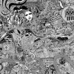
`London Town' by British Artist Fuller, aka Gareth Wood. The original art work is hand drawn using black ink on cotton archival board and measures 92cm x 116cm. The work is a mesmerising kaleidoscope to our association with youth, adolescence and progress into adulthood. Fuller lived, breathed and morphed into the capital to channel its character onto the map.
|
|
| |
 |
|
Unique Hand Drawn Map of London Ten Years in the Making
GfK's Map of the Month for October illustrates the 2015 per-capita purchasing power in the counties of the United States of America (source: GfK). GfK is the trusted source of relevant market and consumer information that enables its clients to make smarter decisions
|
|
| |
 |
|
City of Hamilton Recognized for Increasing Efficiency Using Geospatial Technology
Recently, the City used ArcGIS Online to support their streetlight replacement project and meet eligibility requirements for a $3.5-million provincial grant for converting to cost-effective LED lighting. Leveraging app templates, they quickly developed a mobile app for collecting data on 10,000 municipal streetlights that need replacement.
|
|
| |
 |
|
HOT GeoJob! GIS Manager
Sewall is looking for a candidate that demonstrates an understanding of deploying GIS technology and personnel in a multidisciplinary consulting organization. This person will help create a strategic vision for the group, develop business opportunities, and mentor support staff.
|
|
|
|







