| |  | |
Commercial UAV Expo Europe Announces Early Exhibitors and Other Backers
The event will feature an education program with vertical market tracks in which industry experts share best practices, case studies and challenges. Keynotes and plenary sessions will focus on universal themes including systems selection, workflow integration, legal considerations, regulatory issues, harmonization of standards and more.
|
|
| |  | | Esri 360 – DevSummit Videos
Didn’t manage to get to Palm Springs for DevSummit this year? No worries as Esri has you covered! Enjoy the videos from the event. Enjoy videos from the opening plenary and all the day 1 mainstage presentations
| |
| | 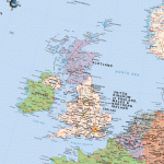 | | Scottish / UK Post Brexit Maps Now Available on Avenza Maps
Recently featured in the Scottish newspaper, The National, the standard EU 2019 – Post Brexit map shows the UK out of the EU. However, the map attracting widespread attention is the alternative Scottish EU 2019 – Post Brexit map as it shows an independent Scotland still a member of the EU, while the reduced UK of England, Wales and Northern Ireland are out.
| |
| |  | | Maptitude 2017 Adds Enhanced MapPoint and Streets & Trips Features
Maptitude 2017 dominates the space vacated by MapPoint®, supporting Microsoft MapPoint-like tools & queries. With enhanced versions of the features that MapPoint users are familiar with, Maptitude retains the ease-of-use of the MapPoint tools while providing functionality that MapPoint users could only wish for.
| |
| |  | | Orbit GT and RIEGL strengthen data interoperability for terrestrial scanning
Orbit GT and RIEGL today strengthen data interoperability for terrestrial scanning by making data exchange between software systems much easier than before. “Orbit GT and RIEGL share a common view that data interoperability should be as easy as possible, also for quite complex and large datasets, as are abundant in the scanning business”, says Peter Bonne, CEO of Orbit GT.
.
| |
| |